
Wake Island
Population
N/A
Area
7 km²
GDP
N/A
GDP Per Capita
N/A
Quick Facts
Currency
$United States dollar(USD)
Calling Code
+268
Primary Timezone
UTC-11:00
Languages
English
Driving Side
right
Demonym
American Islander
Background
Early Micronesian and Polynesian settlers probably visited Wake Island, and oral legends tell of periodic voyages to the islands by people from the Marshall Islands. Wake Island was uninhabited when Spanish explorer Alvaro de Mendana de NEYRA became the first European to see it in 1568 and still had no inhabitants when English captain Samuel WAKE sailed by it in 1796. The United States Exploring Expedition visited the island in 1841, and the US annexed it in 1899 to use as a cable and refueling station for its newly acquired Pacific territories of Hawaii, the Philippines, and Guam. In the 1930s, Pan American Airways built facilities on Wake Island so that it could be used as a stopover for flights from the US to China. In 1941, the US began to install military assets on Wake Island, and Japan then captured the island and held it until the end of World War II. In 1946, commercial airlines resumed using Wake Island as a refueling stop.
In 1973, the Marshall Islands claimed Wake Island, based on the oral legends, although the US has not recognized these claims. In 1974, the US military took exclusive control of the island’s airstrip and restricted visitors. In 1978, Bikini Islanders from the Marshall Islands, who were evacuated in the 1950s and 1960s because of US nuclear tests, considered rehoming on Wake Island, but the US military rejected that plan. Since the 1970s, the island has been important for missile defense testing. In 2009, Wake Island was included in the Pacific Remote Islands Marine National Monument.
Geography16
Location
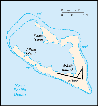
Oceania, atoll in the North Pacific Ocean, about two-thirds of the way from Hawaii to the Northern Mariana Islands
Geographic coordinates
19 17 N, 166 39 E
Map references
Oceania
Area
land: 6.5 sq km
water: 0 sq km
Area - comparative
about 11 times the size of the National Mall in Washington, D.C.
Land boundaries
Coastline
19.3 km
Maritime claims
exclusive economic zone: 200 nm
Climate
tropical
Terrain
atoll of three low coral islands, Peale, Wake, and Wilkes, built up on an underwater volcano; central lagoon is former crater, islands are part of the rim
Elevation
lowest point: Pacific Ocean 0 m
Natural resources
none
Land use
other: 100% (2018 est.)
Irrigated land
0 sq km (2022)
Natural hazards
subject to occasional typhoons
Geography - note
strategic location in the North Pacific Ocean
People & Society1
Population
Government6
Country name
conventional short form: Wake Island
etymology: the name comes from one of two explorers who sighted the islands in the late 1700s; British Captain William WAKE visited in 1792, as did his relative, British Captain Samuel WAKE, in 1796, and sources disagree on which captain claimed the honor of naming the island
Dependency status
unincorporated, unorganized territory of the US; administered by the Department of the Interior; the 11th US Air Force currently conducts activities on the atoll, and it is managed from Pacific Air Force Support Center
Legal system
US common law
Citizenship
see United States
Independence
none (territory of the US)
Flag
the US flag is used
Energy2
Electricity access
Petroleum
Communications1
Broadcast media
US Armed Forces Radio and Television Service (AFRTS) provides satellite radio/TV broadcasts (2018)
Transportation2
Airports
1 (2025)
Ports
total ports
large
medium
small
very small
ports with oil terminals
key ports
Military & Security1
Military - note
defense is the responsibility of the US; the island serves as a trans-Pacific refueling stop for military aircraft and supports US Missile Defense Agency (MDA) testing activities; Wake is managed by the US Air Force (2025)