Spratly Islands
Population
N/A
Area
5 km²
GDP
N/A
GDP Per Capita
N/A
Quick Facts
Currency
KPapua New Guinean kina(PGK)
Calling Code
+675
Timezone
UTC+10:00
Languages
English, Hiri Motu, Tok Pisin
Driving Side
left
Demonym
Papua New Guinean
Background
Historical Trends
GDP (USD)
↑280.6% since 2006Population
↑56.7% since 2006Life Expectancy at Birth
Latest: 66.1 yearsData source: World Bank Open Data
Geography14
Location
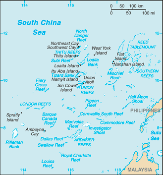
Southeastern Asia, group of reefs and islands in the South China Sea, about two-thirds of the way from southern Vietnam to the southern Philippines
Geographic coordinates
8 38 N, 111 55 E
Map references
Southeast Asia
Area
land: 5 sq km less than
water: 0 sq km
Area - comparative
land area is about seven times the size of the National Mall in Washington, D.C.
Land boundaries
Coastline
926 km
Climate
tropical
Terrain
small, flat islands, islets, cays, and reefs
Elevation
lowest point: South China Sea 0 m
Natural resources
fish, guano, undetermined oil and natural gas potential
Land use
Natural hazards
typhoons; numerous reefs and shoals pose a serious maritime hazard
Geography - note
strategically located near several primary shipping lanes in the central South China Sea; includes numerous small islands, atolls, shoals, and coral reefs
People & Society1
Population
Government1
Country name
conventional short form: Spratly Islands
etymology: named after British whaling captain Richard SPRATLY, who sighted the islands in 1843
Military & Security1
Military - note
China: occupies seven outposts (Fiery Cross, Mischief, Subi, Cuarteron, Gavin, Hughes, and Johnson reefs); the outposts on Fiery Cross, Mischief, and Subi include air bases with helipads and aircraft hangers, naval port facilities, surveillance radars, air defense and anti-ship missile sites, and other military infrastructure such as communications, barracks, maintenance facilities, and ammunition and fuel bunkers
Malaysia: occupies five outposts in the southern portion of the archipelago, closest to the Malaysian state of Sabah (Ardasier Reef, Eric Reef, Mariveles Reef, Shallow Reef, and Investigator Shoal); all the outposts have helicopter landing pads, while Shallow Reef also has an airstrip
Philippines: occupies nine features (Commodore Reef, Second Thomas Shoal, Flat Island, Loaita Cay, Loaita Island, Nanshan Island, Northeast Cay, Thitu Island, and West York Island); Thitu Island has an airstrip and a coast guard station
Taiwan: maintains a coast guard outpost with an airstrip on Itu Aba Island
Vietnam: occupies about 50 outposts, plus some 14 platforms known as “economic, scientific, and technological service stations” (Dịch vụ-Khoa) that sit on underwater banks to the southeast that Vietnam does not consider part of the disputed island chain, although China and Taiwan disagree; Spratly Islands outposts are on Alison Reef, Amboyna Cay, Barque Canada Reef, Central Reef, Collins Reef, Cornwallis South Reef, Discovery Great Reef, East Reef, Grierson Reef, Ladd Reef, Landsdowne Reef, Namyit Island, Pearson Reef, Petley Reef, Sand Cay, Sin Cowe Island, South Reef, Southwest Cay, Spratly Island, Tennent Reef, West Reef; the underwater banks with stations include Vanguard, Rifleman, Prince of Wales, Prince Consort, Grainger, and Alexandra; in recent years, Vietnam has continued to make improvements to its outposts, including defensive positions and infrastructure (2025)
Compare Spratly Islands
See how Spratly Islands compares to other countries side by side.
Compare Countries