Pacific Ocean
Population
N/A
Area
168,723,000 km²
GDP
N/A
GDP Per Capita
N/A
Background
Geography13
Location
body of water between the Southern Ocean, Asia, Australia, and the Western Hemisphere
Geographic coordinates
0 00 N, 160 00 W
Area
Area - comparative
about 15 times the size of the US; covers about 28% of the global surface; almost equal to the total land area of the world
Coastline
135,663 km
Climate
planetary air pressure systems and resultant wind patterns exhibit remarkable uniformity in the south and east; trade winds and westerly winds are well-developed patterns, modified by seasonal fluctuations; tropical cyclones (hurricanes) may form south of Mexico from June to October and affect Mexico and Central America; continental influences cause climatic uniformity to be much less pronounced in the eastern and western regions at the same latitude in the North Pacific Ocean; the western Pacific is monsoonal - a rainy season occurs during the summer months, when moisture-laden winds blow from the ocean over the land, and a dry season during the winter months, when dry winds blow from the Asian landmass back to the ocean; tropical cyclones (typhoons) may strike southeast and east Asia from May to December
Ocean volume
percent of World Ocean total volume: 50.1%
Major ocean currents
the clockwise North Pacific Gyre formed by the warm northward flowing Kuroshio Current in the west, the eastward flowing North Pacific Current in the north, the southward flowing cold California Current in the east, and the westward flowing North Equatorial Current in the south; the counterclockwise South Pacific Gyre composed of the southward flowing warm East Australian Current in the west, the eastward flowing South Pacific Current in the south, the northward flowing cold Peru (Humbolt) Current in the east, and the westward flowing South Equatorial Current in the north
Bathymetry
continental shelf
Arafura Shelf (Figure 5)
Sahul Shelf (Figure 5)
Sunda Shelf (Figure 5)
Taiwan Banks (Figure 5)
continental slope
Pribilof Canyon (Figure 2)
Zhemchug Canyon (Figure 2; deepest submarine canyon)
abyssal plains
Aleutian Basin (Figure 2)
Central Pacific Basin (Figure 2)
Northeast Pacific Basin (Figure 2)
Northwest Pacific Basin (Figure 2)
Philippine Basin (Figure 4)
Southwest Pacific Basin (Figure 4)
Tasman Basin (Figure 4)
mid-ocean ridge
East Pacific Rise (Figure 3)
Pacific-Antarctic Ridge (Figure 3)
undersea terrain features
Caroline Seamounts (Figure 5)
East Mariana Ridge (Figure 4)
Emperor Seamount Chain (Figure 2)
Hawaiian Ridge (Figure 2)
Lord Howe Seamount Chain (Figure 4)
Louisville Ridge (Figure 4)
Kapingamarangi (Ontong-Java) Rise (Figure 5; largest submarine plateau)
Macclesfield Bank (Figure 5)
Marshall Seamounts (Figure 2)
Magellan Seamounts (Figure 2)
Mid-Pacific Seamounts (Figure 2)
Reed Tablemount (Figure 5)
Shatsky Rise (Figure 2; third-largest submarine plateau)
Tonga-Kermadec Ridge (Figure 4)
ocean trenches
Aleutian Trench (Figure 2)
Chile Trench (Figure 3)
Izu-Ogasawara Trench (Figure 2)
Japan Trench (Figure 2)
Kermadec Trench (Figures 3, 4)
Kuril-Kamchatka Trench (Figure 2)
Manus Trench (Figure 4)
Mariana Trench (Figures 2, 4; deepest ocean trench)
Middle America Trench (Figure 3)
Nansei-Shoto Trench (Figure 5)
Palau Trench (Figures 2, 4)
Philippine Trench (Figure 4)
Peru-Chile Trench (Figure 3)
South New Hebrides Trench (Figure 4)
Tonga Trench (Figures 3, 4)
Yap Trench (Figures 2, 4)
atolls
Federated States of Micronesia
French Polynesia
Kiribati
Marshall Islands
Midway Island
Tonga
Tuvalu
Vanuatu
Wake Island
Elevation
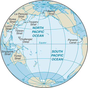
lowest point: Challenger Deep in the Mariana Trench -10,924 m
mean depth: -4,080 m
ocean zones: the ocean is divided into three zones based on depth and light level; sunlight entering the water may travel about 1,000 m into the oceans under the right conditions, but there is rarely any significant light below 200 m
euphotic zone: the upper 200 m (656 ft) is also called "sunlight" zone; only a small amount of light penetrates beyond this depth
dysphotic zone: between 200 m (656 ft) and 1,000 m (3,280 ft), and also called the twilight zone; the intensity of light rapidly dissipates as depth increases, and photosynthesis is no longer possible
aphotic zone: below 1,000 m (3,280 ft) and also called the midnight zone; sunlight does not penetrate to these depths
Natural resources
oil and gas fields, polymetallic nodules, sand and gravel aggregates, placer deposits, fish
Natural hazards
Geography - note
the major chokepoints are the Bering Strait, Panama Canal, Luzon Strait, and the Singapore Strait; the equator divides the Pacific Ocean into the North Pacific Ocean and the South Pacific Ocean; dotted with low coral islands and rugged volcanic islands in the southwestern Pacific Ocean; much of the Pacific Ocean's rim lies along the Ring of Fire, which is a belt that contains about 75% of the world's volcanoes and up to 90% of the world's earthquakes; the Pacific Ocean is the deepest ocean basin, averaging 4,000 m (13,123 ft) in depth
Government1
Country name
Compare Pacific Ocean
See how Pacific Ocean compares to other countries side by side.
Compare Countries