
Lesotho
Kingdom of Lesotho
Population
2.22M
Area
30,355 km²
GDP
$2.27B
GDP Per Capita
$2,600
Pop. Density
73/km²
Quick Facts
Currency
LLesotho loti(LSL)
Calling Code
+266
Timezone
UTC+02:00
Languages
English, Sotho+more
Driving Side
left
Demonym
Mosotho
Background
In 1998, violent protests and a military mutiny following a contentious election prompted a brief but bloody intervention by South African and Batswana military forces under the aegis of the Southern African Development Community (SADC). Subsequent constitutional reforms restored relative political stability. Peaceful parliamentary elections were held in 2002, but the National Assembly elections in 2007 were hotly contested, and aggrieved parties disputed how seats were awarded. In 2012, competitive elections saw Prime Minister Motsoahae Thomas THABANE form a coalition government -- the first in the country's history -- that ousted the 14-year incumbent, Pakalitha MOSISILI, who peacefully transferred power the following month. MOSISILI returned to power in snap elections in 2015 after the collapse of THABANE’s coalition government and an alleged attempted military coup. In 2017, THABANE returned to become prime minister but stepped down in 2020 after being implicated in his estranged wife’s murder. He was succeeded by Moseketsi MAJORO. In 2022, Ntsokoane Samuel MATEKANE was inaugurated as prime minister and head of a three-party coalition.
Historical Trends
GDP (USD)
↑26.2% since 2006Population
↑20.2% since 2006Life Expectancy at Birth
Latest: 57.4 yearsData source: World Bank Open Data
Geography19
Location
Southern Africa, an enclave of South Africa
Geographic coordinates
29 30 S, 28 30 E
Map references
Africa
Area
land: 30,355 sq km
water: 0 sq km
Area - comparative
slightly smaller than Maryland
Land boundaries
border countries: South Africa 1,106 km
Coastline
0 km (landlocked)
Maritime claims
none (landlocked)
Climate
temperate; cool to cold, dry winters; hot, wet summers
Terrain
mostly highland with plateaus, hills, and mountains
Elevation
lowest point: junction of the Orange and Makhaleng Rivers 1,400 m
mean elevation: 2,161 m
Natural resources
water, agricultural and grazing land, diamonds, sand, clay, building stone
Land use
agricultural land
agricultural land: arable land
agricultural land: permanent crops
agricultural land: permanent pasture
forest
other
Irrigated land
12 sq km (2013)
Major rivers (by length in km)
note: [s] after country name indicates river source; [m] after country name indicates river mouth
Major watersheds (area sq km)
Population distribution
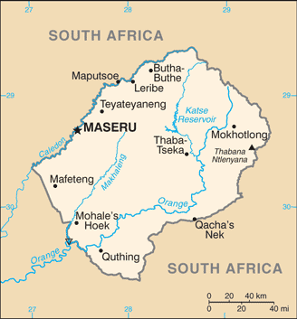
relatively higher population density in the western half of the nation, with the capital of Maseru and the smaller cities of Mafeteng, Teyateyaneng, and Leribe attracting the most people, as shown in this population distribution map
Natural hazards
periodic droughts
Geography - note
landlocked, surrounded by South Africa; mountainous, more than 80% of the country is 1,800 m (5,900 ft) above sea level
People & Society35
Population
male: 1,099,314
female: 1,123,648
Nationality
adjective: Basotho
Ethnic groups
Sotho 99.7%, other 0.3% (includes Kwena, Nguni (Hlubi and Phuthi), Zulu)
Languages
Sesotho (official), English (official), Phuthi, Xhosa, Zulu
Religions
Protestant 47.8% (Pentecostal 23.1%, Lesotho Evangelical 17.3%, Anglican 7.4%), Roman Catholic 39.3%, other Christian 9.1%, non-Christian 1.4%, none 2.3% (2014 est.)
Age structure
15-64 years: 62.7% (male 699,197/female 696,626)
65 years and over: 5.4% (2024 est.) (male 44,625/female 75,345)
Dependency ratios
youth dependency ratio: 48.2 (2025 est.)
elderly dependency ratio: 8.6 (2025 est.)
potential support ratio: 11.6 (2025 est.)
Median age
male: 23.4 years
female: 24.3 years
Population growth rate
0.73% (2025 est.)
Birth rate
21.68 births/1,000 population (2025 est.)
Death rate
10.2 deaths/1,000 population (2025 est.)
Net migration rate
-4.21 migrant(s)/1,000 population (2025 est.)
Population distribution
relatively higher population density in the western half of the nation, with the capital of Maseru and the smaller cities of Mafeteng, Teyateyaneng, and Leribe attracting the most people, as shown in this population distribution map
Urbanization
rate of urbanization: 2.77% annual rate of change (2020-25 est.)
Major urban areas - population
202,000 MASERU (capital) (2018)
Sex ratio
0-14 years: 1.01 male(s)/female
15-64 years: 1 male(s)/female
65 years and over: 0.59 male(s)/female
total population: 0.98 male(s)/female (2024 est.)
Mother's mean age at first birth
Maternal mortality ratio
478 deaths/100,000 live births (2023 est.)
Infant mortality rate
male: 51 deaths/1,000 live births
female: 40.2 deaths/1,000 live births
Life expectancy at birth
male: 58.1 years
female: 62.3 years
Total fertility rate
2.49 children born/woman (2025 est.)
Gross reproduction rate
1.23 (2025 est.)
Drinking water source
improved: urban
improved: rural
improved: total
unimproved: urban
unimproved: rural
unimproved: total
Health expenditure
Health expenditure (as % of national budget): 13.1% of national budget (2022 est.)
Physician density
0.24 physicians/1,000 population (2022)
Sanitation facility access
improved: urban
improved: rural
improved: total
unimproved: urban
unimproved: rural
unimproved: total
Obesity - adult prevalence rate
16.6% (2016)
Alcohol consumption per capita
beer: 1.98 liters of pure alcohol (2019 est.)
wine: 0.44 liters of pure alcohol (2019 est.)
spirits: 0.31 liters of pure alcohol (2019 est.)
other alcohols: 0.82 liters of pure alcohol (2019 est.)
Tobacco use
male: 42.4% (2025 est.)
female: 4.1% (2025 est.)
Children under the age of 5 years underweight
12.5% (2024 est.)
Currently married women (ages 15-49)
46.9% (2021 est.)
Child marriage
women married by age 18: 16.4% (2018)
men married by age 18: 1.9% (2018)
Education expenditure
Education expenditure (% national budget): 10.4% national budget (2024 est.)
Literacy
male: 83.2% (2024 est.)
female: 96.6% (2024 est.)
School life expectancy (primary to tertiary education)
male: 11 years (2017 est.)
female: 11 years (2017 est.)
Government25
Country name
conventional long form
conventional short form
local long form
local short form
former
etymology
Government type
parliamentary constitutional monarchy
Capital
geographic coordinates: 29 19 S, 27 29 E
time difference: UTC+2 (7 hours ahead of Washington, DC, during Standard Time)
etymology: the name means "[place of] red sandstones" in the Sesotho language
Administrative divisions
10 districts; Berea, Butha-Buthe, Leribe, Mafeteng, Maseru, Mohale's Hoek, Mokhotlong, Qacha's Nek, Quthing, Thaba-Tseka
Legal system
mixed system of English common law and Roman-Dutch law; High Court and Court of Appeal review legislative acts
Constitution
amendment process: proposed by Parliament; passage of amendments affecting constitutional provisions, including fundamental rights and freedoms, sovereignty of the kingdom, the office of the king, and powers of Parliament, requires a majority vote by the National Assembly, approval by the Senate, approval in a referendum by a majority of qualified voters, and assent of the king; passage of amendments other than those specified provisions requires at least a two-thirds majority vote in both houses of Parliament
International law organization participation
accepts compulsory ICJ jurisdiction with reservations; accepts ICCt jurisdiction
Citizenship
citizenship by descent only: yes
dual citizenship recognized: no
residency requirement for naturalization: 5 years
Suffrage
18 years of age; universal
Executive branch
head of government: Prime Minister Ntsokoane Samuel MATEKANE (28 October 2022)
cabinet: consists of the prime minister (appointed by the King on the advice of the Council of State), the deputy prime minister, and 18 other ministers; the prime minister is the leader of the majority party or majority coalition in the National Assembly
election/appointment process: the monarchy is hereditary but has no executive or legislative powers under the constitution; under traditional law, the College of Chiefs has the power to depose the monarch, determine next in line of succession, or serve as regent in the event that a successor is not of mature age
Legislative branch
legislative structure: bicameral
Legislative branch - lower chamber
chamber name
number of seats
electoral system
scope of elections
term in office
most recent election date
parties elected and seats per party
percentage of women in chamber
expected date of next election
Legislative branch - upper chamber
chamber name
number of seats
scope of elections
term in office
most recent election date
percentage of women in chamber
expected date of next election
Judicial branch
judge selection and term of office: Court of Appeal president and High Court chief justice appointed by the monarch on the advice of the prime minister; puisne judges appointed by the monarch on advice of the Judicial Service Commission, an independent body of judicial officers and officials designated by the monarch; judges of both courts can serve until age 75
subordinate courts: Magistrate Courts; customary or traditional courts; military courts
Political parties
Alliance of Democrats or AD
Basotho Action Party or BAP
Basotho National Party or BNP
Democratic Congress or DC
Democratic Party of Lesotho or DPL
Lesotho People's Congress or LPC
Movement of Economic Change or MEC
National Independent Party or NIP
Popular Front for Democracy of PFD
Reformed Congress of Lesotho or RCL
Diplomatic representation in the US
chancery: 2511 Massachusetts Avenue NW, Washington, DC 20008
telephone: [1] (202) 797-5533
FAX: [1] (202) 234-6815
email address and website:
[email protected]
https://www.gov.ls/
Diplomatic representation from the US
chief of mission
embassy
mailing address
telephone
FAX
email address and website
International organization participation
ACP, AfDB, AU, C, CD, FAO, G-77, IAEA, IBRD, ICAO, ICCt, ICRM, IDA, IFAD, IFC, IFRCS, ILO, IMF, Interpol, IOC, IOM, IPU, ISO (correspondent), ITU, MIGA, NAM, OPCW, SACU, SADC, UN, UNCTAD, UNESCO, UNHCR, UNIDO, UNWTO, UPU, WCO, WFTU (NGOs), WHO, WIPO, WMO, WTO
Independence
4 October 1966 (from the UK)
National holiday
Independence Day, 4 October (1966)
Flag
meaning: blue stands for rain, white for peace, and green for prosperity
history: the redesigned flag was introduced in 2006 to celebrate 40 years of independence
National symbol(s)
mokorotio (Basotho hat)
National color(s)
blue, white, green, black
National anthem(s)
lyrics/music: Francois COILLARD/Ferdinand-Samuel LAUR
history: adopted 1967; music derives from an 1823 Swiss songbook
National heritage
selected World Heritage Site locales: Maloti-Drakensberg Park
Economy31
Economic overview
lower middle-income economy surrounded by South Africa; environmentally fragile and politically unstable; key infrastructure and renewable energy investments; dire poverty; urban job and income losses due to COVID-19; systemic corruption
Real GDP (purchasing power parity)
Real GDP (purchasing power parity) 2023: $6 billion (2023 est.)
Real GDP (purchasing power parity) 2022: $5.893 billion (2022 est.)
Real GDP growth rate
Real GDP growth rate 2023: 1.8% (2023 est.)
Real GDP growth rate 2022: 2.4% (2022 est.)
Real GDP per capita
Real GDP per capita 2023: $2,600 (2023 est.)
Real GDP per capita 2022: $2,600 (2022 est.)
GDP (official exchange rate)
Inflation rate (consumer prices)
Inflation rate (consumer prices) 2023: 6.3% (2023 est.)
Inflation rate (consumer prices) 2022: 8.3% (2022 est.)
GDP - composition, by sector of origin
industry: 31% (2024 est.)
services: 48% (2024 est.)
GDP - composition, by end use
household consumption
government consumption
investment in fixed capital
investment in inventories
exports of goods and services
imports of goods and services
Agricultural products
Industries
food, beverages, textiles, apparel assembly, handicrafts, construction, tourism
Industrial production growth rate
Labor force
Unemployment rate
Unemployment rate 2023: 16.5% (2023 est.)
Unemployment rate 2022: 16.7% (2022 est.)
Youth unemployment rate (ages 15-24)
male: 17.7% (2024 est.)
female: 36.2% (2024 est.)
Population below poverty line
Gini Index coefficient - distribution of family income
Household income or consumption by percentage share
highest 10%: 32.9% (2017 est.)
Remittances
Remittances 2023: 22.9% of GDP (2023 est.)
Remittances 2022: 22.6% of GDP (2022 est.)
Budget
expenditures: $1.256 billion (2022 est.)
Public debt
Taxes and other revenues
Current account balance
Current account balance 2023: -$151.577 million (2023 est.)
Current account balance 2022: -$268.876 million (2022 est.)
Exports
Exports 2023: $885.789 million (2023 est.)
Exports 2022: $1.07 billion (2022 est.)
Exports - partners
Exports - commodities
Imports
Imports 2023: $2.077 billion (2023 est.)
Imports 2022: $2.247 billion (2022 est.)
Imports - partners
Imports - commodities
Reserves of foreign exchange and gold
Reserves of foreign exchange and gold 2023: $854.089 million (2023 est.)
Reserves of foreign exchange and gold 2022: $771.278 million (2022 est.)
Debt - external
Exchange rates
Currency
Exchange rates 2024
Exchange rates 2023
Exchange rates 2022
Exchange rates 2021
Exchange rates 2020
Energy6
Electricity access
electrification - urban areas: 83.6%
electrification - rural areas: 37.7%
Electricity
consumption: 833.009 million kWh (2023 est.)
imports: 453.992 million kWh (2023 est.)
transmission/distribution losses: 102.88 million kWh (2023 est.)
Electricity generation sources
solar: 0.3% of total installed capacity (2023 est.)
hydroelectricity: 99.6% of total installed capacity (2023 est.)
Coal
consumption: 81,000 metric tons (2023 est.)
exports: 1 metric tons (2023 est.)
imports: 24,000 metric tons (2023 est.)
Petroleum
Energy consumption per capita
Communications6
Telephones - fixed lines
subscriptions per 100 inhabitants: (2023 est.) less than 1
Telephones - mobile cellular
subscriptions per 100 inhabitants: 70 (2024 est.)
Broadcast media
1 state-owned TV station and 2 state-owned radio stations; most private broadcast media transmitters are connected to government radio signal towers; satellite TV subscription service available; transmissions of multiple international broadcasters obtainable (2019)
Internet country code
.ls
Internet users
Broadband - fixed subscriptions
subscriptions per 100 inhabitants: (2023 est.) less than 1
Transportation2
Civil aircraft registration country code prefix
7P
Airports
34 (2025)
Military & Security6
Military and security forces
Military expenditures
Military Expenditures 2023: 1.6% of GDP (2023 est.)
Military Expenditures 2022: 1.6% of GDP (2022 est.)
Military Expenditures 2021: 1.5% of GDP (2021 est.)
Military Expenditures 2020: 1.6% of GDP (2020 est.)
Military and security service personnel strengths
approximately 2,000 active Defense Forces (2025)
Military equipment inventories and acquisitions
the LDF is lightly armed and has a small inventory of mostly older or secondhand equipment of European, South African, and US origin (2025)
Military service age and obligation
20-30 years of age for voluntary military service for both men and women (2026)
Military - note
the Lesotho Defense Force (LDF) is responsible for the maintenance of the country's sovereignty and the preservation of internal security; in practice, external security is guaranteed by South Africa; the LDF is a small force that began in 1964 as the Police Mobile Unit (PMU); the PMU was designated as the Lesotho Paramilitary Force in 1980 and became the Royal Lesotho Defense Force in 1986; it was renamed the Lesotho Defense Force in 1993 (2025)