Heard Island and McDonald Islands
Territory of Heard Island and McDonald Islands
Population
N/A
Area
412 km²
GDP
N/A
GDP Per Capita
N/A
Background
American sailor John HEARD discovered Heard Island in 1853 while fellow American William MCDONALD discovered the McDonald Islands the following year. Starting in 1855, sealers lived on the islands and harvested elephant seal oil; by the time the practice was ended in 1877, most of the islands’ seals were killed. The UK formally claimed the islands in 1910, and Australian explorer Douglas MAWSON visited Heard Island in 1929. In 1947, the UK transferred the islands to Australia for its Antarctica research, but Australia closed the research station on Heard Island in 1954 when it opened a new research station on the Antarctic continent. McDonald Island has been an active volcano since it emerged from dormancy in 1992, and the island doubled in size after an eruption in 1996. In 1997, the islands were named a UNESCO World Heritage site. Populated by a large number of bird species, seals, and penguins, the islands are primarily used for research, with limited fishing permitted in the surrounding waters.
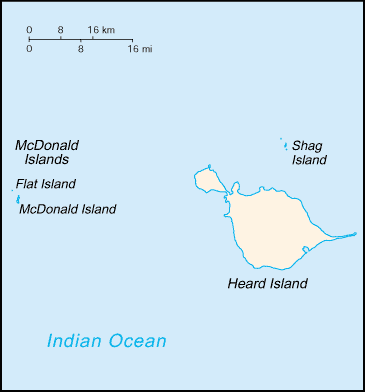
Geography15
Location
islands in the Indian Ocean, about two-thirds of the way from Madagascar to Antarctica
Geographic coordinates
53 06 S, 72 31 E
Map references
Antarctic Region
Area
land: 412 sq km
water: 0 sq km
Area - comparative
slightly more than two times the size of Washington, D.C.
Land boundaries
Coastline
101.9 km
Maritime claims
exclusive fishing zone: 200 nm
Climate
antarctic
Terrain
Heard Island - 80% ice-covered, bleak and mountainous, dominated by a large massif (Big Ben) and an active volcano (Mawson Peak); McDonald Islands - small and rocky
Elevation
lowest point: Indian Ocean 0 m
Natural resources
fish
Land use
other: 100% (2018 est.)
Natural hazards
Mawson Peak, an active volcano, is on Heard Island
Geography - note
Mawson Peak on Heard Island is the highest Australian mountain; at 2,745 m (9,006 ft), Mawson is taller than Mt. Kosciuszko in mainland Australia), and one of only two active volcanoes located in Australian territory; in 1992, McDonald Island, the other active volcano, broke its dormancy and began erupting; it has erupted several times since
People & Society1
Population
Government7
Country name
conventional short form: Heard Island and McDonald Islands
abbreviation: HIMI
etymology: named after US Captain John HEARD, who sighted the island on 25 November 1853, and US Captain William McDONALD, who discovered the islands on 4 January 1854
Dependency status
territory of Australia; administered from Canberra by the Department of Agriculture, Water, and the Environment (Australian Antarctic Division)
Legal system
Diplomatic representation in the US
none (territory of Australia)
Diplomatic representation from the US
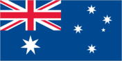
Flag
the flag of Australia is used
National heritage
selected World Heritage Site locales: Heard Island and McDonald Islands
Communications1
Internet country code
.hm
Transportation1
Heliports
2 (2025)
Military & Security1
Military - note
defense is the responsibility of Australia
Compare Heard Island and McDonald Islands
See how Heard Island and McDonald Islands compares to other countries side by side.
Compare Countries