French Southern and Antarctic Lands
Territory of the French Southern and Antarctic Lands
Population
N/A
Area
N/A
GDP
N/A
GDP Per Capita
N/A
Quick Facts
Currency
€euro(EUR)
Calling Code
+262
Timezone
UTC+05:00
Languages
French
Driving Side
right
Demonym
French
Background
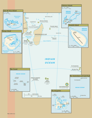
Ile Amsterdam: Discovered but not named in 1522 by the Spanish, the island subsequently received the appellation of Nieuw Amsterdam from a Dutchman; it was claimed by France in 1843. A short-lived attempt at cattle farming began in 1871. A French meteorological station established on the island in 1949 is still in use.
Ile Saint Paul: Claimed by France since 1893, the island was a fishing industry center from 1843 to 1914. In 1928, a spiny lobster cannery was established, but when the company went bankrupt in 1931, seven workers were abandoned. Only two survived until 1934 when rescue finally arrived.
Iles Crozet: A large archipelago formed from the Crozet Plateau, Iles Crozet is divided into two main groups: L'Occidental (the West), which includes Ile aux Cochons, Ilots des Apotres, Ile des Pingouins, and the reefs Brisants de l'Heroine; and L'Oriental (the East), which includes Ile d'Est and Ile de la Possession, the largest island of the Crozets. Discovered and claimed by France in 1772, the islands were used for seal hunting and as a base for whaling. Originally administered as a dependency of Madagascar, they became part of the TAAF in 1955.
Iles Kerguelen: This island group, discovered in 1772, consists of one large island (Ile Kerguelen) and about 300 smaller islands. A permanent group of 50 to 100 scientists resides at the main base at Port-aux-Francais.
Adelie Land: The only non-insular district of the TAAF is the Antarctic claim known as "Adelie Land." The US Government does not recognize it as a French dependency.
Bassas da India: A French possession since 1897, this atoll is a volcanic rock surrounded by reefs and is awash at high tide.
Europa Island: This heavily wooded island has been a French possession since 1897; it is the site of a small military garrison that staffs a weather station.
Glorioso Islands: A French possession since 1892, the Glorioso Islands are composed of two lushly vegetated coral islands (Ile Glorieuse and Ile du Lys) and three rock islets. A military garrison operates a weather and radio station on Ile Glorieuse.
Juan de Nova Island: Named after a famous 15th-century Spanish navigator and explorer, the island has been a French possession since 1897. It has been exploited for its guano and phosphate. Presently a small military garrison oversees a meteorological station.
Tromelin Island: First explored by the French in 1776, the island came under the jurisdiction of Reunion in 1814. At present, it serves as a sea turtle sanctuary and is the site of an important meteorological station.
Geography14
Location
southeast and east of Africa, islands in the southern Indian Ocean, some near Madagascar and others about equidistant between Africa, Antarctica, and Australia; note - French Southern and Antarctic Lands include Ile Amsterdam, Ile Saint-Paul, Iles Crozet, Iles Kerguelen, Bassas da India, Europa Island, Glorioso Islands, Juan de Nova Island, and Tromelin Island in the southern Indian Ocean, along with the French-claimed sector of Antarctica, "Adelie Land"; the US does not recognize the French claim to "Adelie Land"
Geographic coordinates
Ile Saint-Paul (Ile Amsterdam et Ile Saint-Paul): 38 72 S, 77 53 E
Iles Crozet: 46 25 S, 51 00 E
Iles Kerguelen: 49 15 S, 69 35 E
Bassas da India (Iles Eparses): 21 30 S, 39 50 E
Europa Island (Iles Eparses): 22 20 S, 40 22 E
Glorioso Islands (Iles Eparses): 11 30 S, 47 20 E
Juan de Nova Island (Iles Eparses): 17 03 S, 42 45 E
Tromelin Island (Iles Eparses): 15 52 S, 54 25 E
Map references
Africa
Area
Ile Saint-Paul (Ile Amsterdam et Ile Saint-Paul): total - 7 sq km; land - 7 sq km; water - 0 sq km
Iles Crozet: total - 352 sq km; land - 352 sq km; water - 0 sq km
Iles Kerguelen: total - 7,215 sq km; land - 7,215 sq km; water - 0 sq km
Bassas da India (Iles Eparses): total - 80 sq km; land - 0.2 sq km; water - 79.8 sq km (lagoon)
Europa Island (Iles Eparses): total - 28 sq km; land - 28 sq km; water - 0 sq km
Glorioso Islands (Iles Eparses): total - 5 sq km; land - 5 sq km; water - 0 sq km
Juan de Nova Island (Iles Eparses): total - 4.4 sq km; land - 4.4 sq km; water - 0 sq km
Tromelin Island (Iles Eparses): total - 1 sq km; land - 1 sq km; water - 0 sq km
note: excludes "Adelie Land" claim of about 500,000 sq km in Antarctica that is not recognized by the US
Area - comparative
Ile Saint-Paul (Ile Amsterdam et Ile Saint-Paul): more than 10 times the size of the National Mall in Washington, D.C.
Iles Crozet: about twice the size of Washington, D.C.
Iles Kerguelen: slightly larger than Delaware
Bassas da India (Iles Eparses): land area about one-third the size of the National Mall in Washington, D.C.
Europa Island (Iles Eparses): about one-sixth the size of Washington, D.C.
Glorioso Islands (Iles Eparses): about eight times the size of the National Mall in Washington, D.C.
Juan de Nova Island (Iles Eparses): about seven times the size of the National Mall in Washington, D.C.
Tromelin Island (Iles Eparses): about 1.7 times the size of the National Mall in Washington, D.C.
Land boundaries
Coastline
Ile Saint-Paul (Ile Amsterdam et Ile Saint-Paul):
Iles Kerguelen: 2,800 km
Bassas da India (Iles Eparses): 35.2 km
Europa Island (Iles Eparses): 22.2 km
Glorioso Islands (Iles Eparses): 35.2 km
Juan de Nova Island (Iles Eparses): 24.1 km
Tromelin Island (Iles Eparses): 3.7 km
Maritime claims
exclusive economic zone: 200 nm from Iles Kerguelen and Iles Eparses (does not include the rest of French Southern and Antarctic Lands); Juan de Nova Island and Tromelin Island claim a continental shelf of 200-m depth or to the depth of exploitation
Climate
Iles Crozet: windy, cold, wet, and cloudy
Iles Kerguelen: oceanic, cold, overcast, windy
Iles Eparses: tropical
Terrain
Ile Saint-Paul (Ile Amsterdam et Ile Saint-Paul): triangular in shape, the island is the top of a volcano, rocky with steep cliffs on the eastern side; has active thermal springs
Iles Crozet: a large archipelago formed from the Crozet Plateau is divided into two groups of islands
Iles Kerguelen: the interior of the large island of Ile Kerguelen is composed of high mountains, hills, valleys, and plains with peninsulas stretching off its coasts
Bassas da India (Iles Eparses): atoll, awash at high tide; shallow (15 m) lagoon
Europa Island, Glorioso Islands, Juan de Nova Island: low, flat, and sandy
Tromelin Island (Iles Eparses): low, flat, sandy; likely volcanic seamount
Elevation
lowest point: Indian Ocean 0 m
Natural resources
Natural hazards
volcanism: Reunion Island - Piton de la Fournaise (2,632 m), which has erupted many times in recent years, is one of the world's most active volcanoes; although rare, eruptions outside the volcano's caldera could threaten nearby cities
Geography - note
Bassas da India (Iles Éparses): atoll is a circular reef on top of a long-extinct, submerged volcano
Europa Island and Juan de Nova Island (Iles Éparses): wildlife sanctuary for seabirds and sea turtles
Glorioso Island (Iles Éparses): an extensive reef system surrounds the island
Tromelin Island (Iles Éparses): climatologically important location for forecasting cyclones in the western Indian Ocean; wildlife sanctuary (seabirds, tortoises)
People & Society1
Population
Government11
Country name
conventional long form
conventional short form
local long form
local short form
abbreviation
etymology
Dependency status
overseas territory of France since 1955
Administrative divisions
Legal system
the laws of France apply
Citizenship
see France
Executive branch
Diplomatic representation in the US
none (overseas territory of France)
Diplomatic representation from the US
International organization participation
UPU
Flag
the flag of France is used
National anthem(s)
lyrics/music: Claude-Joseph ROUGET de Lisle
history: official anthem, as a French territory
Economy5
Economic overview
very small, fishing-based, domestic economic activity; military base servicing
Exports - partners
Exports - commodities
Imports - partners
Imports - commodities
Communications1
Internet country code
.tf
Transportation3
Airports
4 (2025)
Heliports
3 (2025)
Merchant marine
by type: other 2
Military & Security1
Military - note
Compare French Southern and Antarctic Lands
See how French Southern and Antarctic Lands compares to other countries side by side.
Compare Countries