Cocos (Keeling) Islands
Territory of Cocos (Keeling) Islands
Population
593
Area
14 km²
GDP
N/A
GDP Per Capita
N/A
Pop. Density
42/km²
Background
The UK annexed the islands in 1857 and administered them from Ceylon after 1878 and from Singapore after 1886. The Cocos (Keeling) Islands hosted a cable relaying station and was attacked by the Germans in World War I. The Japanese similarly attacked the islands in World War II. The UK transferred the islands to Australia in 1955, when they were officially named the Cocos (Keeling) Islands, and in 1978, Australia bought all the land held by the Clunies-Ross family, ending their control of the islands. In a referendum in 1984, most islanders voted to integrate with Australia, and Western Australian laws have applied on the islands since 1992.
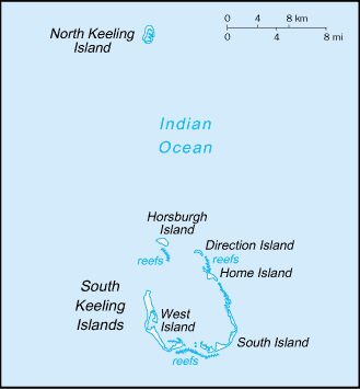
Geography17
Location
Southeastern Asia, group of islands in the Indian Ocean, southwest of Indonesia, about halfway between Australia and Sri Lanka
Geographic coordinates
12 30 S, 96 50 E
Map references
Southeast Asia
Area
land: 14 sq km
water: 0 sq km
Area - comparative
about 24 times the size of the National Mall in Washington, D.C.
Land boundaries
Coastline
26 km
Maritime claims
exclusive fishing zone: 200 nm
Climate
tropical with high humidity, moderated by the southeast trade winds for about nine months of the year
Terrain
flat, low-lying coral atolls
Elevation
lowest point: Indian Ocean 0 m
Natural resources
fish
Land use
forest: 0% (2018 est.)
other: 100% (2018 est.)
Irrigated land
NA
Population distribution
only Home Island and West Island are populated
Natural hazards
cyclone season is October to April
Geography - note
there are 27 coral islands in the group; apart from North Keeling Island, which lies 30 km north of the main group, the islands form a horseshoe-shaped atoll around a lagoon
People & Society9
Population
male: 301
female: 292
Nationality
adjective: Cocos Islander
Ethnic groups
Europeans, Cocos Malays
Languages
major-language sample(s):
Buku Fakta Dunia, sumber yang diperlukan untuk maklumat asas. (Malay)
The World Factbook, the indispensable source for basic information.
Religions
Muslim (predominantly Sunni) 75%, Anglican 3.5%, Roman Catholic 2.2%, none 12.9%, unspecified 6.3% (2016 est.)
Age structure
15-64 years: 61.5%
65 years and over: 17.3% (2021)
Median age
Death rate
8.89 deaths/1,000 population (2021 est.)
Population distribution
only Home Island and West Island are populated
Government19
Country name
conventional short form: Cocos (Keeling) Islands
etymology: the name refers to the abundant coconut trees on the islands and to English Captain William KEELING, the first European to sight the islands in 1609
Government type
non-self-governing overseas territory of Australia
Dependency status
Capital
geographic coordinates: 12 10 S, 96 50 E
time difference: UTC+6.5 (11.5 hours ahead of Washington, DC, during Standard Time)
Legal system
common law based on the Australian model
Constitution
Citizenship
see Australia
Suffrage
18 years of age
Executive branch
head of government: Administrator Farzian ZAINAL (since 11 May 2023)
cabinet: NA
election/appointment process: the monarchy is hereditary; governor general appointed by the monarch on the recommendation of the Australian prime minister; administrator appointed by the governor-general for a 2-year term and represents the monarch and Australia
Legislative branch
legislature name
legislative structure
number of seats
electoral system
scope of elections
term in office
most recent election date
percentage of women in chamber
expected date of next election
Judicial branch
Political parties
none
Diplomatic representation in the US
none (territory of Australia)
Diplomatic representation from the US
International organization participation
none
Independence
none (territory of Australia)
National holiday
Australia Day (commemorates the arrival of the First Fleet of Australian settlers), 26 January (1788)
Flag
the flag of Australia is used
National anthem(s)
lyrics/music: unknown
history: royal anthem, as an Australian territory
Economy7
Agricultural products
vegetables, bananas, pawpaws, coconuts
Industries
copra products, tourism
Exports - partners
Exports - commodities
Imports - partners
Imports - commodities
iron structures, special purpose motor vehicles, cars, ships, aluminum structures (2023)
Exchange rates
Currency
Exchange rates 2024
Exchange rates 2023
Exchange rates 2022
Exchange rates 2021
Exchange rates 2020
Communications3
Broadcast media
1 local radio station staffed by community volunteers; satellite broadcasts of several Australian radio and TV stations available (2017)
Internet country code
.cc
Internet users
Transportation1
Airports
1 (2025)
Military & Security1
Military - note
defense is the responsibility of Australia
Compare Cocos (Keeling) Islands
See how Cocos (Keeling) Islands compares to other countries side by side.
Compare Countries