Christmas Island
Territory of Christmas Island
Population
1.7K
Area
135 km²
GDP
N/A
GDP Per Capita
N/A
Pop. Density
13/km²
Quick Facts
Currency
$Australian dollar(AUD)
Calling Code
+61
Timezone
UTC+07:00
Languages
English+more
Driving Side
left
Demonym
Christmas Islander
Background
Japan invaded the island in 1942, but islanders sabotaged Japanese mining operations, making the mines relatively unproductive. After World War II, Australia and New Zealand bought the company mining the phosphate, and in 1958, the UK transferred sovereignty from Singapore to Australia in exchange for $20 million to compensate for the loss of future phosphate income. In 1980, Australia set up the Christmas Island National Park and expanded its boundaries throughout the 1980s until it covered more than 60% of the island’s territory. The phosphate mine was closed in 1987 because of environmental concerns, and Australia has rejected several efforts to reopen it.
In the 1980s, boats of asylum seekers started landing on Christmas Island, and the migrants claimed refugee status because they were on Australian territory. In 2001, Australia declared Christmas Island to be outside the Australian migration zone and built an immigration detention center on the island. Completed in 2008, the controversial detention center was closed in 2018 but then reopened in 2019. In 2020, the center served as a coronavirus quarantine facility for Australian citizens evacuated from China.
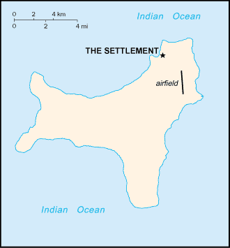
Geography17
Location
Southeastern Asia, island in the Indian Ocean, south of Indonesia
Geographic coordinates
10 30 S, 105 40 E
Map references
Southeast Asia
Area
land: 135 sq km
water: 0 sq km
Area - comparative
about three-quarters the size of Washington, D.C.
Land boundaries
Coastline
138.9 km
Maritime claims
contiguous zone: 12 nm
exclusive fishing zone: 200 nm
Climate
tropical with a wet season (December to April) and dry season; heat and humidity moderated by trade winds
Terrain
steep cliffs along coast rise abruptly to central plateau
Elevation
lowest point: Indian Ocean 0 m
Natural resources
phosphate, beaches
Land use
other: 100% (2018 est.)
Irrigated land
NA
Population distribution
majority of the population lives on the northern tip of the island
Natural hazards
the narrow fringing reef surrounding the island can be a maritime hazard
Geography - note
located along major sea lanes of the Indian Ocean
People & Society9
Population
male: 1,007
female: 685
Nationality
adjective: Christmas Island
Ethnic groups
Languages
Religions
Muslim 19.4%, Buddhist 18.3%, Roman Catholic 8.8%, Protestant 6.5% (includes Anglican 3.6%, Uniting Church 1.2%, other 1.7%), other Christian 3.3%, other 0.6%, none 15.3%, unspecified 27.7% (2016 est.)
Age structure
15-64 years: 70.4%
65 years and over: 13% (2021)
Median age
Population growth rate
1.11% (2014 est.)
Population distribution
majority of the population lives on the northern tip of the island
Government20
Country name
conventional short form: Christmas Island
etymology: named by English Captain William MYNORS for the day of its rediscovery, Christmas Day (25 December 1643); Europeans had sighted the island as early as 1615
Government type
non-self-governing overseas territory of Australia
Dependency status
Capital
geographic coordinates: 10 25 S, 105 43 E
time difference: UTC+7 (12 hours ahead of Washington, DC, during Standard Time)
etymology: Flying Fish Cove was named after a British explorer's ship in 1886
Legal system
system is under the authority of the governor general of Australia and Australian law
Constitution
Citizenship
see Australia
Suffrage
18 years of age
Executive branch
head of government: Administrator Farzian ZAINAL (since 11 May 2023)
cabinet: NA
election/appointment process: the monarchy is hereditary; governor general appointed by the monarch on the recommendation of the Australian prime minister; administrator appointed by the governor-general of Australia for a 2-year term and represents the monarch and Australia
Legislative branch
legislature name
legislative structure
number of seats
electoral system
scope of elections
term in office
most recent election date
parties elected and seats per party
percentage of women in chamber
expected date of next election
Judicial branch
Political parties
none
Diplomatic representation in the US
none (territory of Australia)
Diplomatic representation from the US
International organization participation
none
Independence
none (territory of Australia)
National holiday
Australia Day (commemorates the arrival of the First Fleet of Australian settlers), 26 January (1788)
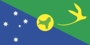
Flag
National symbol(s)
golden bosun bird
National anthem(s)
lyrics/music: unknown
history: royal anthem, as an Australian territory
Economy7
Economic overview
Industries
tourism, phosphate extraction (near depletion)
Exports - partners
Exports - commodities
Imports - partners
Imports - commodities
Exchange rates
Currency
Exchange rates 2024
Exchange rates 2023
Exchange rates 2022
Exchange rates 2021
Exchange rates 2020
Communications3
Broadcast media
1 community radio station; satellite broadcasts of several Australian radio and TV stations (2017)
Internet country code
.cx
Internet users
Transportation3
Airports
1 (2025)
Railways
standard gauge: 18 km (2017) 1.435-m (not in operation)
Ports
total ports
large
medium
small
very small
ports with oil terminals
key ports
Military & Security1
Military - note
defense is the responsibility of Australia
Compare Christmas Island
See how Christmas Island compares to other countries side by side.
Compare Countries