
Anguilla
Population
19.4K
Area
91 km²
GDP
$452.73M
GDP Per Capita
$31,000
Pop. Density
213/km²
Quick Facts
Currency
$Eastern Caribbean dollar(XCD)
Calling Code
+1264
Timezone
UTC-04:00
Languages
English+more
Driving Side
left
Demonym
Anguillian
Background
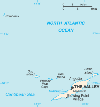
Geography17
Location
Caribbean, islands between the Caribbean Sea and North Atlantic Ocean, east of Puerto Rico
Geographic coordinates
18 15 N, 63 10 W
Map references
Central America and the Caribbean
Area
land: 91 sq km
water: 0 sq km
Area - comparative
about one-half the size of Washington, D.C.
Land boundaries
Coastline
61 km
Maritime claims
exclusive economic zone: 200 nm
exclusive fishing zone: 200 nm
Climate
tropical; moderated by northeast trade winds
Terrain
flat and low-lying island of coral and limestone
Elevation
lowest point: Caribbean Sea 0 m
Natural resources
salt, fish, lobster
Land use
agricultural land
agricultural land: arable land
agricultural land: permanent crops
agricultural land: permanent pasture
forest
other
Irrigated land
0 sq km (2020)
Population distribution
most of the population is concentrated in The Valley in the center of the island; settlement is fairly uniform in the southwest, but rather sparse in the northeast
Natural hazards
frequent hurricanes and other tropical storms (July to October)
Geography - note
the most northerly of the Leeward Islands in the Lesser Antilles
People & Society23
Population
male: 9,107
female: 10,309
Nationality
adjective: Anguillan
Ethnic groups
Languages
English (official)
Religions
Protestant 73.2% (includes Anglican 22.7%, Methodist 19.4%, Pentecostal 10.5%, Seventh Day Adventist 8.3%, Baptist 7.1%, Church of God 4.9%, Presbyterian 0.2%, Brethren 0.1%), Roman Catholic 6.8%, Jehovah's Witness 1.1%, other Christian 10.9%, other 3.2%, unspecified 0.3%, none 4.5% (2011 est.)
Age structure
15-64 years: 67.5% (male 5,958/female 7,147)
65 years and over: 11.7% (2024 est.) (male 1,093/female 1,170)
Dependency ratios
youth dependency ratio: 30.9 (2024 est.)
elderly dependency ratio: 17.3 (2024 est.)
potential support ratio: 5.8 (2024 est.)
Median age
male: 34.8 years
female: 39 years
Population growth rate
1.71% (2025 est.)
Birth rate
11.69 births/1,000 population (2025 est.)
Death rate
4.76 deaths/1,000 population (2025 est.)
Net migration rate
10.13 migrant(s)/1,000 population (2025 est.)
Population distribution
most of the population is concentrated in The Valley in the center of the island; settlement is fairly uniform in the southwest, but rather sparse in the northeast
Urbanization
rate of urbanization: 0.47% annual rate of change (2020-25 est.)
Major urban areas - population
1,000 THE VALLEY (capital) (2018)
Sex ratio
0-14 years: 1.03 male(s)/female
15-64 years: 0.83 male(s)/female
65 years and over: 0.93 male(s)/female
total population: 0.88 male(s)/female (2024 est.)
Infant mortality rate
male: 3.9 deaths/1,000 live births
female: 2.1 deaths/1,000 live births
Life expectancy at birth
male: 80 years
female: 85.3 years
Total fertility rate
1.72 children born/woman (2025 est.)
Gross reproduction rate
0.85 (2025 est.)
Drinking water source
Physician density
1.51 physicians/1,000 population (2018)
Education expenditure
Education expenditure (% national budget): 10.3% national budget (2024 est.)
Government21
Country name
conventional short form: Anguilla
etymology: in 1493, Christopher COLUMBUS named the island Anguilla, meaning "eel" in Spanish, because of the island's elongated shape
Government type
parliamentary democracy (House of Assembly); self-governing overseas territory of the UK
Dependency status
overseas territory of the UK
Capital
geographic coordinates: 18 13 N, 63 03 W
time difference: UTC-4 (1 hour ahead of Washington, DC, during Standard Time)
etymology: name may derive from the capital's location among several hills
Legal system
common law based on the English model
Constitution
Citizenship
see United Kingdom
Suffrage
18 years of age; universal
Executive branch
head of government: Premier Cora RICHARDSON-HODGE (since 27 February 2025)
cabinet: Executive Council appointed by the governor from among elected members of the House of Assembly
election/appointment process: the monarchy is hereditary; governor appointed by the monarch; following legislative elections, the governor usually appoints the leader of the majority party or majority coalition as premier
Legislative branch
legislature name
legislative structure
number of seats
electoral system
scope of elections
term in office
most recent election date
parties elected and seats per party
percentage of women in chamber
Judicial branch
judge selection and term of office: Eastern Caribbean Supreme Court chief justice appointed by the British monarch; other justices and judges appointed by the Judicial and Legal Services Commission; Court of Appeal justices appointed for life with mandatory retirement at age 65; High Court judges appointed for life with mandatory retirement at age 62
subordinate courts: Magistrate's Court; Juvenile Court
Political parties
Anguilla United Front or AUF
Diplomatic representation in the US
none (overseas territory of the UK)
Diplomatic representation from the US
International organization participation
Caricom (associate), CDB, Interpol (subbureau), OECS, UNESCO (associate), UPU
Independence
none (overseas territory of the UK)
National holiday
Anguilla Day, 30 May (1967)
Flag
meaning: the white on the coat of arms stands for peace; the blue base for the sea, faith, youth, and hope; and the three dolphins for endurance, unity, and strength
National symbol(s)
dolphin
National coat of arms
the Anguillan coat of arms features three interlocking dolphins jumping out of seawater; they represent endurance, unity, and strength, and their circular motion stands for continuity; the white background symbolizes peace and tranquility, and the turquoise-blue base represents the sea, as well as faith, youth, and hope
National anthem(s)
lyrics/music: unknown
history: official anthem, as an overseas UK territory
Economy15
Economic overview
small, tourism-dependent, territorial-island economy; very high public debt; COVID-19 crippled economic activity; partial recovery underway via tourism, benefitting from its high amount of timeshare residences; considering reopening oil refinery
Real GDP (purchasing power parity)
Real GDP (purchasing power parity) 2023: $345.238 million (2023 est.)
Real GDP (purchasing power parity) 2022: $336.924 million (2022 est.)
Real GDP per capita
Real GDP per capita 2023: $28,900 (2023 est.)
Real GDP per capita 2022: $27,400 (2022 est.)
GDP (official exchange rate)
Inflation rate (consumer prices)
Inflation rate (consumer prices) 2021: 1.8% (2021 est.)
Inflation rate (consumer prices) 2020: -0.5% (2020 est.)
Agricultural products
small quantities of tobacco, vegetables; cattle raising
Industries
tourism, boat building, offshore financial services
Budget
expenditures: $72.352 million (2017 est.)
Public debt
Exports
Exports 2016: $3.9 million (2016 est.)
Exports - partners
Exports - commodities
Imports - partners
Imports - commodities
Exchange rates
Currency
Exchange rates 2024
Exchange rates 2023
Exchange rates 2022
Exchange rates 2021
Exchange rates 2020
Energy1
Electricity access
Communications6
Telephones - fixed lines
subscriptions per 100 inhabitants: 38 (2021 est.)
Telephones - mobile cellular
subscriptions per 100 inhabitants: 163 (2022 est.)
Broadcast media
1 private TV station; multi-channel cable TV subscription services are available; about 10 radio stations, one of which is government-owned (2024)
Internet country code
.ai
Internet users
Broadband - fixed subscriptions
subscriptions per 100 inhabitants: 35 (2018 est.)
Transportation3
Civil aircraft registration country code prefix
VP-A
Airports
1 (2025)
Merchant marine
by type: other 2
Military & Security1
Military - note
defense is the responsibility of the UK